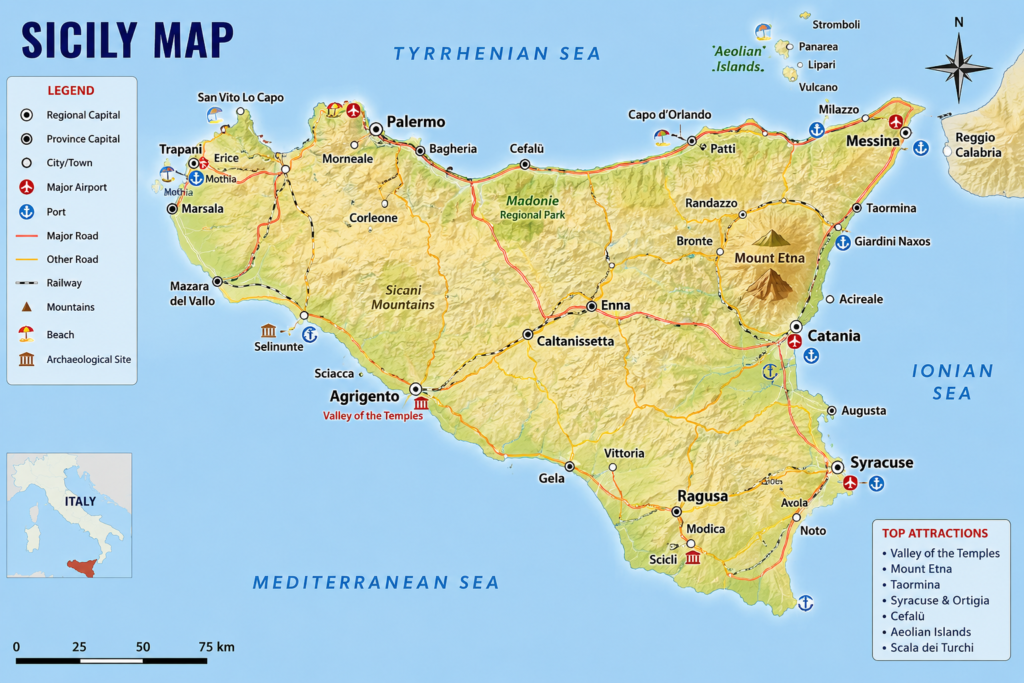
If you’re planning a trip to Sicily or simply curious about Italy’s largest island, having a good Sicily map can completely change the way you experience the region. Sicily is packed with ancient ruins, coastal towns, volcanoes, vineyards, and charming cities, so understanding the island’s geography makes traveling much easier.
A Sicily map is more than just roads and landmarks. It helps you connect the island’s history, culture, and landscapes into one unforgettable journey. Whether you’re visiting for food, beaches, architecture, or adventure, learning how Sicily is laid out will save you time and help you discover places many tourists miss.
In this guide, we’ll explore Sicily’s geography, major cities, famous attractions, travel routes, and how to use a Sicily map effectively for your next adventure.
Where Is Sicily Located?
Sicily sits just off the southern tip of Italy in the Mediterranean Sea. The island is separated from mainland Italy by the Strait of Messina.
When you look at a Sicily map, you’ll notice its triangular shape, which is one reason ancient Greeks called it “Trinacria,” meaning “three corners.”
Sicily’s Geographic Highlights
- Located in southern Italy
- Surrounded by the Mediterranean Sea
- Close to Malta and North Africa
- Home to Mount Etna, Europe’s tallest active volcano
- Features mountains, beaches, and historic cities
Because of its strategic location, Sicily has been influenced by Greek, Roman, Arab, Norman, and Spanish civilizations over thousands of years.
Understanding a Sicily Map
At first glance, Sicily may seem straightforward, but the island is surprisingly diverse.
A good Sicily map usually highlights:
- Major cities
- Coastal highways
- Mountain regions
- Historic sites
- Beaches
- Ports and airports
- National parks
Understanding these areas helps travelers plan routes more efficiently.
Major Cities on a Sicily Map
Palermo
Palermo is Sicily’s capital and one of the island’s most vibrant cities. Located on the northern coast, it blends architecture, street food, and history into one energetic destination.
Highlights of Palermo
- Palermo Cathedral
- Ballarò Market
- Norman Palace
- Street food culture
- Historic piazzas
On a Sicily map, Palermo serves as a major transportation hub.
Catania
Located on the eastern side of the island near Mount Etna, Catania is famous for volcanic landscapes and lively nightlife.
Why Travelers Love Catania
- Proximity to Mount Etna
- Baroque architecture
- Seafood cuisine
- Vibrant city atmosphere
- Black volcanic beaches
Catania also has one of Sicily’s busiest airports.
Syracuse
Syracuse is located on Sicily’s southeastern coast and is known for ancient Greek ruins and coastal beauty.
Top Attractions
- Ortigia Island
- Greek Theater
- Archaeological Park
- Seaside dining
- Historic streets
A Sicily map often marks Syracuse as one of the island’s key historical destinations.
Taormina
Taormina is one of Sicily’s most famous tourist towns. Perched on cliffs overlooking the sea, it offers incredible views and luxury charm.
Famous Features
- Ancient Greek theater
- Luxury hotels
- Coastal scenery
- Boutique shopping
- Mount Etna views
Many visitors consider Taormina a must-see location on any Sicily map.
Mount Etna on the Sicily Map
One of Sicily’s defining landmarks is Mount Etna.
Located near Catania, this active volcano dominates eastern Sicily and shapes much of the surrounding landscape.
Why Mount Etna Matters
- Europe’s tallest active volcano
- Popular hiking destination
- Volcanic wine region
- Frequent eruptions
- Stunning photography location
A Sicily map clearly shows Etna’s importance because many roads and nearby towns revolve around it.
Sicily’s Coastal Areas
Sicily has some of the Mediterranean’s most beautiful coastlines.
Northern Coast
Known for:
- Palermo
- Cefalù
- Rocky beaches
- Historic ports
Eastern Coast
Famous for:
- Taormina
- Mount Etna
- Luxury resorts
- Scenic cliffs
Southern Coast
Features:
- Quieter beaches
- Ancient ruins
- Relaxed atmosphere
- Agricultural landscapes
Western Coast
Popular for:
- Trapani
- Salt flats
- Island ferries
- Seafood culture
A detailed Sicily map helps travelers compare these coastal regions easily.
Best Attractions to Mark on a Sicily Map
If you’re building your own travel itinerary, these destinations deserve attention.
Valley of the Temples
Located in Agrigento, this archaeological site contains some of the best-preserved Greek temples in the world.
Cefalù
A picturesque coastal town famous for beaches and medieval charm.
Aeolian Islands
Volcanic islands north of Sicily known for stunning scenery and boat tours.
Scala dei Turchi
White limestone cliffs that create one of Sicily’s most photographed landscapes.
Villa Romana del Casale
Famous for incredibly preserved Roman mosaics.
Road Trips Around Sicily
One of the best ways to experience Sicily is by road trip.
A Sicily map becomes incredibly useful when planning driving routes between cities and coastal towns.
Popular Sicily Road Trip Route
Route Example
- Palermo
- Cefalù
- Messina
- Taormina
- Catania
- Syracuse
- Agrigento
- Trapani
This loop covers many of Sicily’s highlights while offering varied landscapes and experiences.
Transportation Across Sicily
Traveling across Sicily is relatively easy, especially with proper planning.
Transportation Options
Rental Cars
Best for:
- Rural exploration
- Beach hopping
- Flexible schedules
Trains
Useful between:
- Palermo
- Catania
- Syracuse
- Messina
Buses
Affordable but slower for long-distance travel.
Ferries
Important for:
- Aeolian Islands
- Nearby Mediterranean islands
A transport-focused Sicily map can simplify navigation dramatically.
Food Regions on the Sicily Map
Food lovers often use Sicily maps differently — to discover culinary regions.
Western Sicily
Known for:
- Couscous dishes
- Seafood
- Arab influences
Eastern Sicily
Popular for:
- Pistachios
- Etna wines
- Fresh seafood
Southern Sicily
Famous for:
- Almond desserts
- Traditional pastries
- Farm-to-table cuisine
Beaches Worth Finding on a Sicily Map
Sicily has beaches for every type of traveler.
Best Beach Areas
San Vito Lo Capo
White sand and crystal-clear water.
Isola Bella
Tiny island beach near Taormina.
Mondello Beach
Popular near Palermo.
Cala Rossa
Dramatic turquoise water.
Marina di Ragusa
Family-friendly atmosphere.
Hidden Gems on a Sicily Map
Beyond famous destinations, Sicily also offers quieter treasures.
Lesser-Known Places
- Erice
- Noto
- Modica
- Scicli
- Marzamemi
These towns provide authentic Sicilian culture away from heavy tourist crowds.
Digital Sicily Maps vs Paper Maps
Modern travelers often rely on digital apps, but paper maps still have advantages.
Digital Maps
Pros:
- GPS navigation
- Real-time updates
- Traffic information
Cons:
- Battery dependence
- Weak rural signals
Paper Maps
Pros:
- Better big-picture planning
- No internet required
- Easier route visualization
Many travelers combine both options for the best experience.
Why Sicily Fascinates Travelers
Sicily isn’t just another Italian destination.
It feels like multiple worlds blended together:
- Greek history
- Arab influences
- Italian culture
- Mediterranean landscapes
- Volcanic scenery
A Sicily map helps reveal how diverse the island truly is.
Tips for Using a Sicily Map Efficiently
Plan by Region
Don’t try to see everything at once. Divide the island into manageable areas.
Watch Mountain Roads
Some inland routes take longer than expected due to winding roads.
Prioritize Attractions
Sicily has countless attractions, so focus on what interests you most.
Stay Flexible
Unexpected discoveries often become the best travel memories.
FAQs About Sicily Map
Where is Sicily located on the map?
Sicily is located south of mainland Italy in the Mediterranean Sea.
What is the best city to start a Sicily trip?
Many travelers begin in Palermo or Catania because both cities have major airports.
Is Sicily easy to explore by car?
Yes, driving is one of the best ways to explore Sicily, especially smaller towns and coastal areas.
What are the most famous places on a Sicily map?
Popular destinations include Palermo, Taormina, Mount Etna, Syracuse, and Agrigento.
How large is Sicily?
Sicily is the largest island in the Mediterranean Sea.
Are Sicily maps useful for tourists?
Absolutely. A good Sicily map helps travelers organize routes, attractions, and transportation options efficiently.
Final Thoughts
A Sicily map is much more than a navigation tool. It’s a gateway into one of Europe’s most fascinating destinations.
From volcanic landscapes to ancient ruins and stunning beaches, Sicily offers experiences that feel both historical and deeply alive. Every region has its own personality, cuisine, architecture, and traditions.
Whether you’re planning a luxury vacation, a backpacking adventure, or a cultural road trip, understanding Sicily’s layout helps you travel smarter and appreciate the island more fully.
And honestly, once you start exploring Sicily .even on a map .it’s easy to see why so many travelers fall in love with it.